-
Recent Posts
Recent Comments
Archives
Categories
Meta
Monthly Archives: September 2011
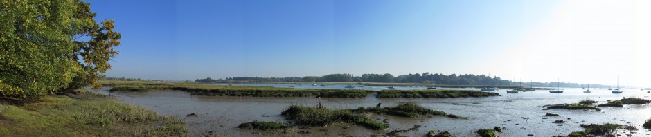
Iken and Snape Maltings
OS Explorer Map 212 coordinates 41 56 for Iken, 39 57 for Snape Maltings I’ve wanted to ride to Iken since I saw a beautiful photograph looking across the River Alde to Iken church. I wanted to see that river … Continue reading
Posted in Aldeburgh, River Alde
Tagged Butley, Chillesford, Iken, Orford, Rendlesham, Snape, Sudbourne
Comments Off on Iken and Snape Maltings
Ipswich marina, Holywells and Nacton
This ride owes a lot to the Ipswich Cycle Route Map (a freebie) and Sustrans NCR routes 1 and 51. I did 20 miles today, most of it on well mapped and signposted NCRs. I set out for Ipswich marina just … Continue reading
Posted in Ipswich, River Orwell
Tagged Ipswich, Kesgrave, Nacton
Comments Off on Ipswich marina, Holywells and Nacton
Landguard Point, Felixstowe
OS Explorer Map 197 coordinates 28 31 for Landguard Point. This was 31 miles with great views of the port, the fort and a wander around Landguard nature reserve. The route description is appropriately long and winding, so here are … Continue reading
Hemley
OS Explorer map 197 coordinates 285 425 for Hemley church. I like Hemley. Its got a few houses, a church and a phone box, lots of stripey rolling fields and distant-ish views of the Deben. Its kind of a dead … Continue reading
Debenham
OS Explorer Map 211 coordinates 17 63 I accidentally bought the “all weather” version of this map, which means its plasticised, which is great for holding off rain but rubbish for folding out to the little bit I was interested in … Continue reading
Martlesham Creek
OS Explorer Map 212 coordinates 26 47. Martlesham creek sounds to me like there should be gold diggers working in it, but I don’t believe there are. Near the creek the map shows the interestingly named “Troublesome Reach” and “Mean High … Continue reading
Posted in River Deben, Woodbridge
Tagged Deben, Kesgrave, Kyson, Martlesham
Comments Off on Martlesham Creek
Loompit and Levington
This ride picks up from a previous Trimley outing that ended early with a puncture. That day I left the Orwell behind me at Loompit Lake and trudged up the track back to the village. Today my first task was … Continue reading
Posted in Felixstowe, River Orwell
Tagged Kesgrave, Levington, Trimley
Comments Off on Loompit and Levington
Waldringfield crab catching
OS Explorer map 197 Waldringfield coordinates 285 445, Martlesham Heath coordinates 245 555 This is an easy lunchtime ride for me of about 11 miles. There’s only one small hill towards the Waldringfield golf club and your reward will be … Continue reading
Posted in River Deben, Woodbridge
Tagged Deben, Martlesham, Newbourne, Waldringfield
Comments Off on Waldringfield crab catching
